
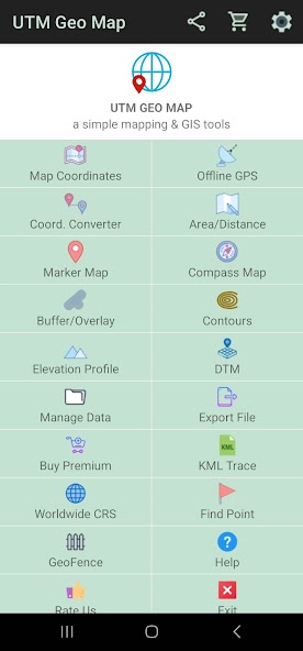
Simple Mapping & GIS Tools.
Complete, simple, easy to use & free application for Land Surveying, Topography, Bathymetry & GIS. Adecuado para ingeniería de geodesía, ingeniería civil, geología y otras disciplinas relacionadas con mapas, coordenadas, ubicación, dirección y análisis espacial. Se puede utilizar como una herramienta para determinar la posición, las coordenadas, la ubicación y la dirección, la medición del área y la distancia, el análisis espacial simple como la superposición, el búfer, la triangulación de estaño / delaunay, el diagrama de voronoi, el casco convexo, suavizado, show wms map (servidor de mapas), etc., etc.
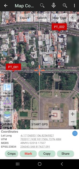
Map Coordinates : Can be used to obtain Latitude Longitude, UTM, MGRS (WGS84) & other CRS (using EPSG codes) in real time, register points complete with coordinate data, time taken, notes/labels, elevation (premium), addresses, photos etc. This module can also display TIN, Voronoi Diagrams and Buffers in realtime from existing points.
Offline GPS : Used to get coordinates in an offline state (without internet access), your cellphone will function like a Handheld GPS to get Latitude Longitude coordinates, UTM, MGRS, Elevation (ellipsoid), MSL Elevation (EGM96), accuracy, satellite and other useful information. Los datos de las coordenadas se pueden almacenar en un número ilimitado dentro de sus bases de datos, dadas notas / etiquetas, fotos o exportados a formatos CSV, KML, DXF y GPX.
Coord. Converter : To convert coordinates manually from Latitude Longitude to UTM & MGRS and vice versa. It can also be used to convert addresses to coordinates (Geocoding, requires an internet connection). Some conversion is support for batch conversion.
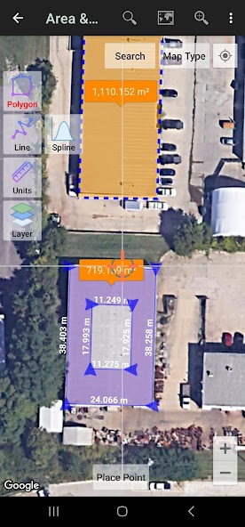
Area/Distance : Used to measure distance and area (support units: m, km, ft, miles, hectare, acre), register lines / polygons, make polygons automatically from measure points, create buffers from lines / polygons, overlay etc.. Line / polygon data can be stored in unlimited number inside your database, displayed on a map, added photos and labels or exported to CSV, KML or DXF format. Equipado con algoritmos de edición espacial, como Snap más cercano, Eliminar objeto dentro / fuera de polígono, suavizado (interpolación cúbica de Bezier), polígono dividido por línea, etc. Can read CSV & KML formats to import or display as reference files.
Marker Map : Similar to the Map Coordinates module but with more complete & complex geometry calculation such as displaying Dynamic / Variable Buffers. En este módulo, el análisis geométrico, como los diagramas de estaño y voronoi, se pueden hacer a partir de una combinación de datos de puntos (marcadores), así como líneas y polígonos (línea de interrupción). These geometries can also be exported to KML or DXF files for use on other devices or PC.
Compass Map : Module with a map and compass with magnetic declination, can be used to assist in navigating or measuring the azimuth angle and determining distance & direction.
Buffer/Overlay : Module to perform buffering & overlays (and other GIS operations) with several options including Union, Intersection, Difference and Symmetrical Difference.
Elevation Profile : Used to create simple elevation profiles (cross section / long section) from height data with metric & ft / mile units. This module can also create elevation profiles from multiple points including elevation profile from route (premium).
Contours : Module to generate contours based on number of contour lines, desired elevation or contour interval. This is premium module & need internet connection.
DTM : Digital Terrain Model, module to generate TIN / GRID surface & Contour Lines from elevation data. Calculate Cut And Fill volume, TIN refinement, Grid interpolation and dynamic Elevation Profile.
Some other modules.
Website: https://www.utmgeomap.com
Quick guide (pdf): https://www.utmgeomap.com/utmgeomapquickstart.pdf
YouTube: https://www.youtube.com/channel/UCspxQ5nQiqRD88g_-6GcCqw
Any suggestions are welcome, please submit via email to [email protected] or write a review. Gracias.
 Descargar APK(12.32MB)